Troposphere parameter estimation
Following Resolution 1 of the EUREF 2008 symposium in Brussels, the Troposphere Special Project was discontinued and integrated in the routine EPN operations, see Products & Services > Tropospheric Delays.
Introduction
Within the routine analysis of a network of ground-based GPS receivers, the tropospheric parameters are a by-product of the parameter estimation. These zenith path delays (ZPD) can be used for meteorological purposes in two ways:
- long series of (post-processed) ZPD can be used for climate monitoring and climate research;
- near real-time processing can be used within numerical weather prediction (NWP).
The extended network of EPN permanent stations, with its high number of Local Analysis Centres (LAC), is well suited for
contributing to these investigations.
Therefore EUREF decided to create a Special Project "Troposphere Parameter Estimation".
Chair of the project is Dr. W. Soehne, Federal Agency for Cartography and
Geodesy (BKG), Germany. He is responsible for the project coordination and the generation of the EUREF ZPD product.
- Project members and participation
- Processing strategy
- Station Distribution
- Zenith Path Delay (vector)
- Zenith Path Delay (map)
Project members and participation
This project is fully suported by the EUREF Local Analayis Centres. They provide ZPD estimates for the EPN stations in the subnetwork they are analysing routinely within the frame of the reference frame maintenance.
The following institutions are participating to the project by delivering different types of solutions (status: GPS week 1119):
| Acronym | Agency | Solutions | Starting from (GPS week) |
|---|---|---|---|
| ASI | Centro di Geodesia Spaziale, Italy | daily | 1110 |
| BEK | Bayerische Kommission für die Internationale Erdmessung, Germany | daily | 1120 |
| BKG | Bundesamt für Kartographie und Geodäsie, Germany | daily | 1108 |
| BKG | Bundesamt für Kartographie und Geodäsie, Germany | weekly combined | 1110 |
| COE | Astronomical Institute of the University of Bern, Switzerland | daily | 1110 |
| DEO | Delft University of Technology, The Netherlands | daily | 1130 |
| GFZ | GeoForschungsZentrum Potsdam, Germany | weekly combined | 1110 |
| GOP | Geodetic Observatory Pecny, Czech Republic | daily | 1115 |
| IGE | Instituto Geografico Nacional de Espana, Spain | daily | 1126 |
| IGN | Institut Géographique National, France | daily | 1111 |
| LPT | Bundesamt für Landestopographie, Switzerland | daily | 1111 |
| NKG | Nordic Geodetic Commission GPS data Analysis Center, Sweden | daily | 1114 |
| OLG | Institute for Space Research (ISR/ASS), Graz, Austria | daily | 1112 |
| ROB | Royal Observatory of Belgium, Brussels, Belgium | daily | 1130 |
| SGO | FOMI Satellite Geodetic Observatory, Budapest, Hungary | daily | 1143 |
| SUT | Slovak University of Technology, Bratislava, Slovakia | daily | 1185 |
| UPA | University of Padova, Italy | daily | 1109 |
| WUT | Warsaw University of Technology, Poland | daily | 1113 |
Processing strategy
In the first step a combined troposphere solution is produced in post-processing mode
similar to the combination of the SINEX files for the derivation of a combined
coordinate product. The EPN LACs contribute to the project with daily troposphere solutions
on the basis of precise orbits. The combination is carried out following
today's IGS standards: epoch-wise combination of the individual solutions as
weighted mean with rigorous outlier detection in consecutive steps. Biases
between the individual solutions and the mean have to be taken into account;
this way jumps will be avoided if single observations of the individual
solutions were missed.
As result two weekly files are produced:
- one summary file (EURwwwwd.TSU) with some statistics about e.g. frequencies of the analyzed sites and accuracies of a single AC solution, providing the feedback to the contributing LACs, and
- the output file (EURwwwwd.TRO) containing the combined troposphere estimates with a two hours sampling rate. The coordinates as a necessary part of this file, are taken from EUREF's official combined SINEX file.
The files can be downloaded from the EUREF product directory at BKG since GPS week 1110.
In GPS week 1110, the first combination was done with the solutions of four LACs. Only few of the stations, mainly IGS stations, were processed by three or more LACs, some of the stations were processed by two LACs, most stations were processed by one LAC only. But this will improve with more LACs contributing with their individual troposphere solutions. Stations without estimated coordinates in the weekly SINEX file are not included in the combined troposphere solutions.
The differences between the two combination solutions of GFZ and BKG are small (mean over all sites < 0.1 mm ZPD). They might stem from the slightly different kind of weighting as well as from some differences in outlier detection. And from the fact that the resolution of the ZPD values in the files is just ± 0.1 mm, of course.
Future points of interest will be some investigations
- on the size of the biases between the individual LAC and the mean solution,
- if there is a station dependency of these biases and
- methods for reducing the biases, e.g. by introducing troposphere estimates for certain stations taken from global IGS solutions.
Station distribution
Within GPS week 1115 the following ten LACs were contributing to the EUREF troposphere combination: ASI, BKG, COE, GOP, IGN, LPT, NKG, OLG, UPA and WUT. This results in the following station distribution :

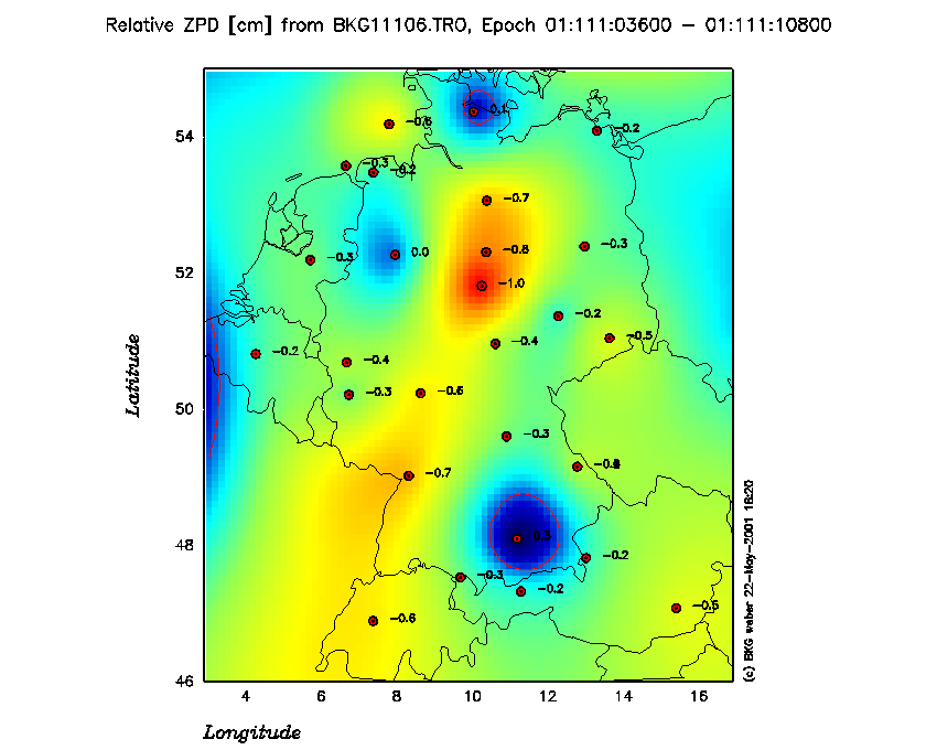
Zenith Path Delay
The following map of Germany shows the relative ZPD values with respect to the one particular reference epoch within GPS week 1113. This way the changes in the tropospheric behaviour can better be seen as if the absolute values would be plotted.

To see an animated scene of the change of ZPDS during 24 hours over Germany click here.
The following picture shows the ZPD values for one station for one GPS week. The IGS station Wettzell is taken as an example because most of the LAC's are processing this site. The plots shows and evidences the weighted mean and the individual solutions. The biases of the individual LAC ZPD solutions with respect to the mean.
